


Dictionary

Portolano
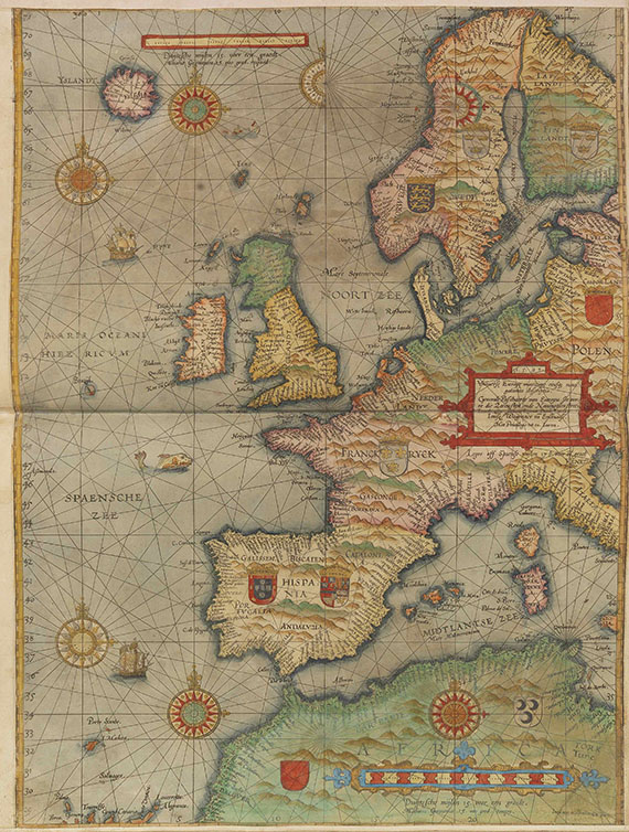
A portolano or rhumb chart (also compass chart, ruttier book) is a medieval nautical map (for coastal navigation) on which lines are drawn from a point at the centre to the directions of the compass or the winds. By the 17th century, rhumb charts were an indispensable part of navigators' handbooks (portolani). Providing in continuous sequence detailed descriptions of coasts, they were an important navigational aid.
A portolano or rhumb chart (also compass chart, ruttier book) is a medieval nautical map (for coastal navigation) on which lines are drawn from a point at the centre to the directions of the compass or the winds. By the 17th century, rhumb charts were an indispensable part of navigators' handbooks (portolani). Providing in continuous sequence detailed descriptions of coasts, they were an important navigational aid.
Offers for Geography and travel
Headquarters
Joseph-Wild-Str. 18
81829 Munich
Phone: +49 89 55 244-0
Fax: +49 89 55 244-177
info@kettererkunst.de
Louisa von Saucken / Undine Schleifer
Holstenwall 5
20355 Hamburg
Phone: +49 40 37 49 61-0
Fax: +49 40 37 49 61-66
infohamburg@kettererkunst.de
Dr. Simone Wiechers / Nane Schlage
Fasanenstr. 70
10719 Berlin
Phone: +49 30 88 67 53-63
Fax: +49 30 88 67 56-43
infoberlin@kettererkunst.de
Cordula Lichtenberg
Gertrudenstraße 24-28
50667 Cologne
Phone: +49 221 510 908-15
infokoeln@kettererkunst.de
Hessen
Rhineland-Palatinate
Miriam Heß
Phone: +49 62 21 58 80-038
Fax: +49 62 21 58 80-595
infoheidelberg@kettererkunst.de
We will inform you in time.