


466
Großbritannien
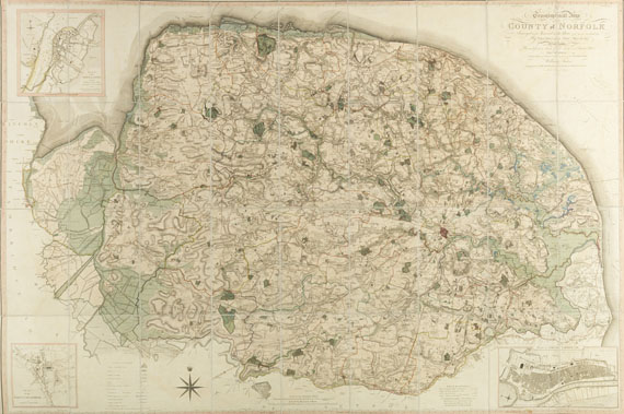
Map of the county of Norfolk (Wandkarte), 1797.
Estimate:
€ 1,000 / $ 1,180 Sold:
€ 2,706 / $ 3,193 (incl. surcharge)
Großbritannien
A Topographical map of the County of Norfolk surveyed and measured in the years 1790-94. Grenz- und flächenkolorierter Kupferstich nach Th. Donald und Th. Milne bei William Faden, London 1797. In 36 Segmente geteilt und auf 1 Stück Leinwand aufgezogen (124 : 184 cm), gefaltet in zeitgenössischem Leder-Steckschuber.
Großformatige Karte des County Norfolk.
Detaillierte Regionalkarte, in drei Ecken mit den Insets Plan of the Town of Lynn , Plan of the Town of Swaffham und Plan of Great Yarmouth . - William Faden (1749-1836) war Partner und Nachfolger von Thomas Jeffrys (Jeffrys and Faden , London) und Königlicher Geograph für George III. und dem Prince Regent. Der Schwerpunkt seiner beachtlichen kartographischen Produktion lag auf Nordamerika, ferner schuf seine Firma zahlreiche Land- und Seekarten und Atlanten. "His contribution to the development of cartography was considerable, commissioning new surveys and publishing the work of mapmakers throughout Europe." (Tooley, Mapmakers II, 45)
- ZUSTAND: Leicht gebräunt durch Abklatsch der Farben, nur vereinz. fleckig. Schuber berieben.
Detailled map of the county of Norfolk. Copper engraving with outline and surface coloring, published by William Faden. With 3 insets of King's Lynn, of Swaffham and of Great Yarmouth. Dissected in 36 parts, laid down on 1 piece of cloth (overall size 124 : 184 cm), folded and in contemp. calf slipcase. - Only slightly tanned by offset of colors, here and there stained.Slipcase rubbed.

466
Großbritannien
Map of the county of Norfolk (Wandkarte), 1797.
Estimate:
€ 1,000 / $ 1,180 Sold:
€ 2,706 / $ 3,193 (incl. surcharge)
Headquarters
Joseph-Wild-Str. 18
81829 Munich
Phone: +49 89 55 244-0
Fax: +49 89 55 244-177
info@kettererkunst.de
Louisa von Saucken / Undine Schleifer
Holstenwall 5
20355 Hamburg
Phone: +49 40 37 49 61-0
Fax: +49 40 37 49 61-66
infohamburg@kettererkunst.de
Dr. Simone Wiechers / Nane Schlage
Fasanenstr. 70
10719 Berlin
Phone: +49 30 88 67 53-63
Fax: +49 30 88 67 56-43
infoberlin@kettererkunst.de
Cordula Lichtenberg
Gertrudenstraße 24-28
50667 Cologne
Phone: +49 221 510 908-15
infokoeln@kettererkunst.de
Hessen
Rhineland-Palatinate
Miriam Heß
Phone: +49 62 21 58 80-038
Fax: +49 62 21 58 80-595
infoheidelberg@kettererkunst.de
We will inform you in time.