


25
Vincenzo Maria Coronelli
Conquiste della Serenissima Republica di Venezia, 1686.
Post auction sale: € 4,500 / $ 5,085
Aus dem Großen Türkenkrieg
Vincenzo Maria Coronelli
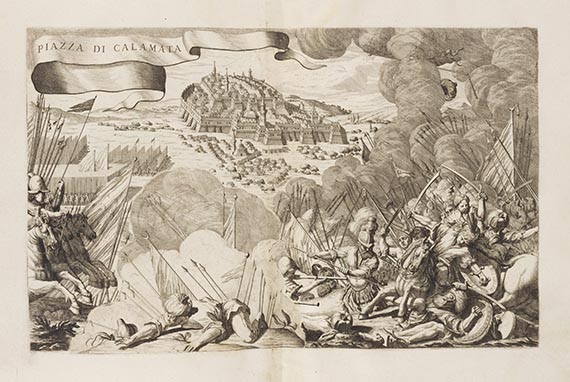
Conquiste della Ser. Republica di Venezia nella Dalmazia, Epiro, e Morea durante la Guerra intrapresa contro Meemet IV Imper. de Turchi. 4 Teile in 1 Bd. Venedig 1686.
• Erstes kartographisches Werk Coronellis aus der Zeit der Türkenkriege
• Erste Ausgabe
• Die Festungspläne und -karten teils mit prächtigen Schmuckbordüren
• Gezeigt sind die Hauptorte in Griechenland und dem südlichen Balkan
Selten, nur 1 weiteres Exemplar auf dem international Auktionsmarkt der letzten 20 Jahre. Behandelt die militärischen Auseinandersetzungen 1684 zwischen der Republik Venedig (als Mitglied der Heiligen Liga ) und dem Osmanischen Reich während des Großen Türkenkriegs (1683-1699). Die Republik konnte 1684 erfolgreich die bisher besetzte Halbinsel Morea erobern und so dem Vorrücken der Osmanen tlw. Einhalt gebieten. Die Tafeln zeigen die wichtigsten Festungen in Griechenland und im südlichen Balkan. Die den vier Teilen vorangestellten Kupfertitel jeweils mit Widmung an einen venezianischen Feldherrn. - Coronelli war 1685 zum Kosmographen der Republik Venedig ernannt worden. Blackmer listet und beschreibt mehrere Werke, die Coronelli 1686-1688 über den Morea-Konflikt herausgab, in variierender Zusammensetzung. "The plates in any work by Coronelli present a problem, as he added and substracted or changed plates as he saw fit; he also used the same series of plates in different combinations which he dedicated to various important political figures in Venice" (Blackmer S. 86).
EINBAND: Pergamentband der Zeit. 40,5 : 28 cm. - ILLUSTRATION: Mit gest. Halbtitel, gest. Titel mit Bordüre, 4 gest. Zwischentiteln, 28 doppelblattgr. Kupfertafeln (von 29; davon 11 mit Schmuckbordüre) und 8 halbseitigen Textkupfern. - KOLLATION: 23 Bll. - ZUSTAND: Fehlt die Tafel Nr. 29 Canale di Cattaro . Wasserrandig, Hauptkupfertitel im unt. weißen Rand abgeschnitten, feste Vorsätze und gest. Halbtitel (im oberen w. Rand) mit säuberlichen und umfangr. Eintragungen in Italienisch von zeitgenöss. Hand, vord. Innendeckel mit farbigem Buchhändler-Stempel (Rom). Einbd. berieben, Vorderdeckel leicht geworfen.
LITERATUR: Blackmer 409 Anm. - Cicogna 972 Anm.
Scarce, only 1 copy on the international auction market in the last 20 years. First edition. Coronolli's first work about the war between the Osmanian empire and the Holy League consisting of Austria, Poland and the Venetian Republik. 4 parts in 1 volume. With engr. half title, engr. title with ornamental border, 4 engr. titles to the separate sections, 28 (of 29) doublepage plates (11 of which with decorative borders), and 8 half page text engravings. Contemp. vellum. - Lacking plate 29 "Canale di Cattaro". Engr. title with border trimmed to lower platemark. Waterstained. Pastedowns and upper white margin of half title wiht neat inscription in Italian by a contemporary hand, front board with bookshop stamp on inside. Binding rubbed, front board slightly warped. (R)
Vincenzo Maria Coronelli
Conquiste della Ser. Republica di Venezia nella Dalmazia, Epiro, e Morea durante la Guerra intrapresa contro Meemet IV Imper. de Turchi. 4 Teile in 1 Bd. Venedig 1686.
• Erstes kartographisches Werk Coronellis aus der Zeit der Türkenkriege
• Erste Ausgabe
• Die Festungspläne und -karten teils mit prächtigen Schmuckbordüren
• Gezeigt sind die Hauptorte in Griechenland und dem südlichen Balkan
Selten, nur 1 weiteres Exemplar auf dem international Auktionsmarkt der letzten 20 Jahre. Behandelt die militärischen Auseinandersetzungen 1684 zwischen der Republik Venedig (als Mitglied der Heiligen Liga ) und dem Osmanischen Reich während des Großen Türkenkriegs (1683-1699). Die Republik konnte 1684 erfolgreich die bisher besetzte Halbinsel Morea erobern und so dem Vorrücken der Osmanen tlw. Einhalt gebieten. Die Tafeln zeigen die wichtigsten Festungen in Griechenland und im südlichen Balkan. Die den vier Teilen vorangestellten Kupfertitel jeweils mit Widmung an einen venezianischen Feldherrn. - Coronelli war 1685 zum Kosmographen der Republik Venedig ernannt worden. Blackmer listet und beschreibt mehrere Werke, die Coronelli 1686-1688 über den Morea-Konflikt herausgab, in variierender Zusammensetzung. "The plates in any work by Coronelli present a problem, as he added and substracted or changed plates as he saw fit; he also used the same series of plates in different combinations which he dedicated to various important political figures in Venice" (Blackmer S. 86).
EINBAND: Pergamentband der Zeit. 40,5 : 28 cm. - ILLUSTRATION: Mit gest. Halbtitel, gest. Titel mit Bordüre, 4 gest. Zwischentiteln, 28 doppelblattgr. Kupfertafeln (von 29; davon 11 mit Schmuckbordüre) und 8 halbseitigen Textkupfern. - KOLLATION: 23 Bll. - ZUSTAND: Fehlt die Tafel Nr. 29 Canale di Cattaro . Wasserrandig, Hauptkupfertitel im unt. weißen Rand abgeschnitten, feste Vorsätze und gest. Halbtitel (im oberen w. Rand) mit säuberlichen und umfangr. Eintragungen in Italienisch von zeitgenöss. Hand, vord. Innendeckel mit farbigem Buchhändler-Stempel (Rom). Einbd. berieben, Vorderdeckel leicht geworfen.
LITERATUR: Blackmer 409 Anm. - Cicogna 972 Anm.
Scarce, only 1 copy on the international auction market in the last 20 years. First edition. Coronolli's first work about the war between the Osmanian empire and the Holy League consisting of Austria, Poland and the Venetian Republik. 4 parts in 1 volume. With engr. half title, engr. title with ornamental border, 4 engr. titles to the separate sections, 28 (of 29) doublepage plates (11 of which with decorative borders), and 8 half page text engravings. Contemp. vellum. - Lacking plate 29 "Canale di Cattaro". Engr. title with border trimmed to lower platemark. Waterstained. Pastedowns and upper white margin of half title wiht neat inscription in Italian by a contemporary hand, front board with bookshop stamp on inside. Binding rubbed, front board slightly warped. (R)

25
Vincenzo Maria Coronelli
Conquiste della Serenissima Republica di Venezia, 1686.
Post auction sale: € 4,500 / $ 5,085
Buyer's premium and taxation for Vincenzo Maria Coronelli "Conquiste della Serenissima Republica di Venezia"
This lot can only be purchased subject to regular taxation.
Regular taxation:
Hammer prices up to € 200,000: 25 % buyer's premium. Hammer prices above € 200,000: for the share up to € 200,000: 25%, for the share above € 200.000: 20% buyer's premium.
The statutory VAT of currently 7 % is levied to the sum of hammer price and premium.
Regular taxation:
Hammer prices up to € 200,000: 25 % buyer's premium. Hammer prices above € 200,000: for the share up to € 200,000: 25%, for the share above € 200.000: 20% buyer's premium.
The statutory VAT of currently 7 % is levied to the sum of hammer price and premium.
Headquarters
Joseph-Wild-Str. 18
81829 Munich
Phone: +49 89 55 244-0
Fax: +49 89 55 244-177
info@kettererkunst.de
Louisa von Saucken / Undine Schleifer
Holstenwall 5
20355 Hamburg
Phone: +49 40 37 49 61-0
Fax: +49 40 37 49 61-66
infohamburg@kettererkunst.de
Dr. Simone Wiechers / Nane Schlage
Fasanenstr. 70
10719 Berlin
Phone: +49 30 88 67 53-63
Fax: +49 30 88 67 56-43
infoberlin@kettererkunst.de
Cordula Lichtenberg
Gertrudenstraße 24-28
50667 Cologne
Phone: +49 221 510 908-15
infokoeln@kettererkunst.de
Hessen
Rhineland-Palatinate
Miriam Heß
Phone: +49 62 21 58 80-038
Fax: +49 62 21 58 80-595
infoheidelberg@kettererkunst.de
We will inform you in time.